Main Menu
AORC Libraries
MEDMAPS
Dublin Core
Title
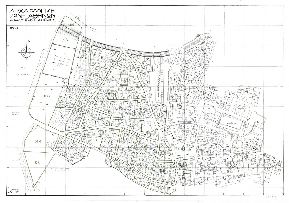
Archaeological zone of Athens
Description
Printed map by Ka[lligas?].
48 x 70 cm.
Scale 1:500.
This map shows an area of the city of Athens expropriated for archaeological excavation. In fact it is a map of the Agora and Theseion sections of Athens that shows us what the area was like in 1936, after five years of excavations by the American School of Classical Studies. This tremendous series of excavations, which are continuing today, have revealed the reality of the ancient Agora of Athens, that "assembly-place par excellence where the citizens of Athens met daily in the open air for all purposes of community life... it became the recognized venue for the transaction of business or the discussion of philosophy... St. Paul disputed in the Agora daily with them that met with him" (– Blue Guide). The map is of the area between the Kifissia-Piraeus railway line and the Acropolis, which was declared an archaeological zone by law (law no. 4212) in the mid-1920s.
The American School of Classical Studies in Athens was founded in 1882. Its chief project in Athens has been the excavation of the area of the Agora, a tremendous undertaking. Proposals for the excavations began as early as 1924. In 1926 the Archaeological Section of the Ministry of Education published a pamphlet by K. Kourouniotes preparing the groundwork for public acceptance of the American School initiative, and in 1927 the Greek Government proposed that the American School should pay for the expropriated properties and undertake the excavation of the area. By 1928 the negotiations were successfully concluded. The expropriations began with the financial support of John D. Rockefeller, Jr., and excavations began in 1931 in an exploratory manner. In 1934 the most important initial discoveries began to be made. As far as the system of expropriation was concerned, each year from 1931 to 1940 certain blocks of houses were chosen for expropriation. It is clear from a surviving document in the Gennadius Library of the American School of Classical Studies, which includes a much reduced but similar map of the area, that the householders were not satisfied with the suggested payments for their properties and that as early as 1930 they had formed a committee to fight the expropriations. This map appears to depict the extent of the expropriations and the initial finds which had appeared by 1936; the fact that the caption is in Greek only might indicate that the map was prepared for the Greek committee.
The American School of Classical Studies in Athens was founded in 1882. Its chief project in Athens has been the excavation of the area of the Agora, a tremendous undertaking. Proposals for the excavations began as early as 1924. In 1926 the Archaeological Section of the Ministry of Education published a pamphlet by K. Kourouniotes preparing the groundwork for public acceptance of the American School initiative, and in 1927 the Greek Government proposed that the American School should pay for the expropriated properties and undertake the excavation of the area. By 1928 the negotiations were successfully concluded. The expropriations began with the financial support of John D. Rockefeller, Jr., and excavations began in 1931 in an exploratory manner. In 1934 the most important initial discoveries began to be made. As far as the system of expropriation was concerned, each year from 1931 to 1940 certain blocks of houses were chosen for expropriation. It is clear from a surviving document in the Gennadius Library of the American School of Classical Studies, which includes a much reduced but similar map of the area, that the householders were not satisfied with the suggested payments for their properties and that as early as 1930 they had formed a committee to fight the expropriations. This map appears to depict the extent of the expropriations and the initial finds which had appeared by 1936; the fact that the caption is in Greek only might indicate that the map was prepared for the Greek committee.
Publisher
Athens, 1936.
Date
1936
Contributor
From the collection of the W. F. Albright Institute of Archaeological Research (Jerusalem), Map 21-21-1.
Collection
Dublin Core XML
Citation
"Archaeological zone of Athens," online in Digital Library for International Research Archive, Item #13, http://www.dlir.org/archive/items/show/13 (accessed July 22, 2026).