Main Menu
AORC Libraries
MEDMAPS
Dublin Core
Title
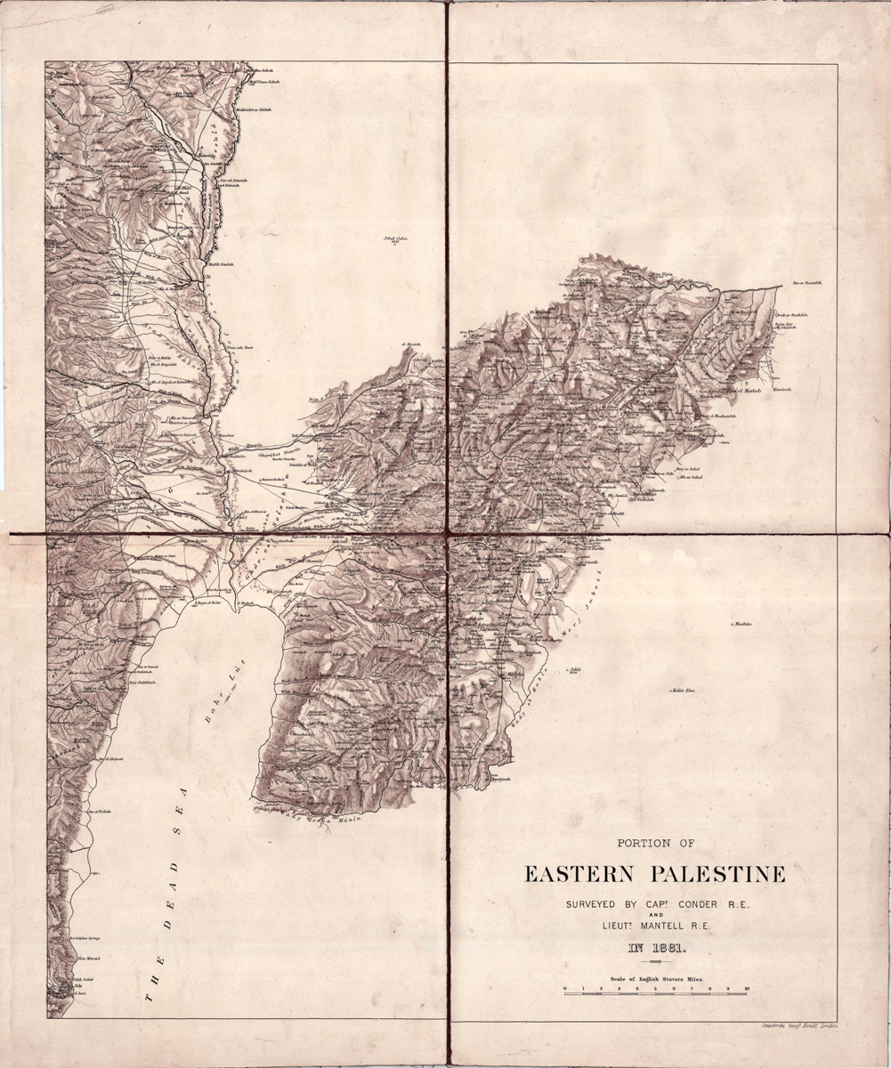
Portion of Eastern Palestine
Description
Map by Claude R. Conder.
50 x 41 cm.
This map is an example of the work of the great explorer of Palestine, Claude Reignier Conder (1848-1910), grandson of the polymath and writer Josiah Conder. He was a career officer in the British Army, Royal Engineers, and as a student was known for his surveying, his geometrical work and his free-hand drawing. In 1872 he was selected to head the scientific survey of Western Palestine, under the auspices of the Palestine Exploration Fund, which had begun surveying Jerusalem some seven years earlier. He began work in July 1872. The survey, after much danger and hardship, was completed in 1877 by H. H. Kitchener, after an attack by Arab tribes resulted in Conder’s being invalided back to England in 1875. In 1881 Conder resumed work for the P. E. F., surveying east of the Jordan. The survey was conducted in August, September and October of 1881, and a survey of about 500 square miles was completed, from the Jordan River to Amman. The survey had to be limited because of hostilities in Lebanon. The members of the survey party included A. M. Mantell, T. Black and G. Armstrong, under the command of Conder, who was completely fluent in Arabic. In 1883 he published a popular account of the survey under the title Heth and Moab, Explorations in Syria in 1881 and 1882. Not only was Conder a capable surveyor, but he was interested in the history and archaeology of the areas he surveyed. In addition to actual mapping, he collected information regarding topography, ethnography and archaeology, and identified many places mentioned in the Bible and previously unknown. Conder also devoted himself to the languages of the country and to the decipherment of ancient inscriptions.
The first publication date of Conder’s map of Eastern Palestine is unclear; the map may have been published separately sometime after 1881. It certainly was published in connection with the official publication of the survey: The Survey of Eastern Palestine. Memoirs of the Topography, Orography, Hydrography, Archaeology etc., which appeared in 1889, published by the Palestine Exploration Fund, where the map is found in a pocket in the binding of the work. The Palestine Exploration Fund was the moving force behind archaeological work in Palestine and Jerusalem. The first survey of Jerusalem was made by a group of volunteers, mainly army engineers, in an effort to supply a water system for the city: this was the start of the Palestine Exploration Fund. This unofficial body funded archaeological work in Palestine for many years. Its many publications include the Ordnance Survey of Jerusalem, The Survey of Western Palestine, Excavations in Jerusalem, 1867-1870, and The Survey of Eastern Palestine.
The first publication date of Conder’s map of Eastern Palestine is unclear; the map may have been published separately sometime after 1881. It certainly was published in connection with the official publication of the survey: The Survey of Eastern Palestine. Memoirs of the Topography, Orography, Hydrography, Archaeology etc., which appeared in 1889, published by the Palestine Exploration Fund, where the map is found in a pocket in the binding of the work. The Palestine Exploration Fund was the moving force behind archaeological work in Palestine and Jerusalem. The first survey of Jerusalem was made by a group of volunteers, mainly army engineers, in an effort to supply a water system for the city: this was the start of the Palestine Exploration Fund. This unofficial body funded archaeological work in Palestine for many years. Its many publications include the Ordnance Survey of Jerusalem, The Survey of Western Palestine, Excavations in Jerusalem, 1867-1870, and The Survey of Eastern Palestine.
Publisher
London: Stanford’s Geographical Establishment, ca. 1881.
Date
1881
Contributor
From the collection of the W. F. Albright Institute of Archaeological Research (Jerusalem), map dr.22, 22-00-14a.
Collection
Dublin Core XML
Citation
"Portion of Eastern Palestine," online in Digital Library for International Research Archive, Item #9, http://www.dlir.org/archive/items/show/9 (accessed July 29, 2026).