Main Menu
AORC Libraries
MEDMAPS
Dublin Core
Title
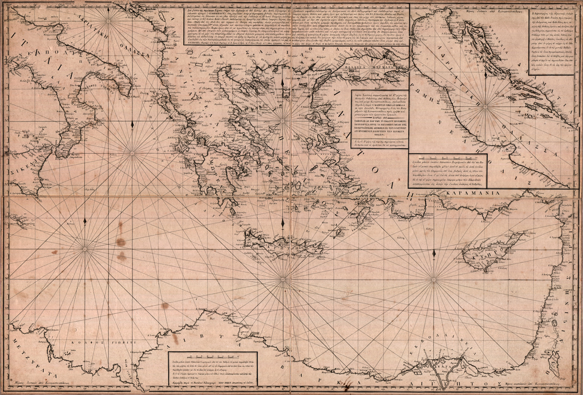
[Nautical chart of the second part of the Mediterranean Sea, from Malta to Alexandretta and up to Constantinople, carefully drawn by Captain Nikolaos Kefalas, of Zakynthos Island.]
Description
Engraved map by Nikolaos Kefalas.
99 x 67.5 cm.
99 x 67.5 cm.
This nautical chart is one of three charts of the Mediterranean, published by the sea captain Nikolaos Kefalas of Zakynthos. Although Greek pilots like Antonio da Millo and George Sideris ‘Kalapodas’ produced manuscript portolan charts from the late 16th century, this may be the first printed chart of the Mediterranean to be issued by a Greek; It is extremely rare and may be known only by the copy in the Gennadius Library.
Kefalas (1770-1850), from the island of Zakynthos, dedicated his charts to the newly founded Sept-Insular Republic of the Ionian Islands. At the same time as he published the maps, he also published a separate dedicatory letter to the government of the Ionian Islands, in fact a form of advertisement, in which he refers to these maps and states that the geographer and cartographer J. D. Barbie du Bocage, together with the Greek literateur Adamantios Koraes, helped him publish them. The price of the three maps bound together was 10 'grossia'.
According to this pamphlet he also published a chart of the Black Sea in 1817 in Vienna, together with a book on nautical law. Kefalas was clearly an adventurer. He is an ambiguous figure in the history of Greek marine activity: not only did he sail to India in 1824, but he made a voyage to America in 1820 on a brigantine he had built in Russa; he may have been the first Greek to sail to America. He also represented Ali Mirtsa of Persia on several diplomatic missions.
However, Kefalas’s self advertisement has to be taken with a large grain of salt. Although he claimed to produce his maps and nautical works for the good of his native land, he was unscrupulous in his use of others’ works. (He published as his own a translation the work of the Indian philosopher Chanakya, which had been entrusted to him for publication by the Greek philosopher and indologist Demetrios Galanos.)
The cartography of the chart produced by Kefalas is peculiar. The shape of Greece is very curious for this period. Notice the extremely narrow shape of the mainland, and the way in which Cape Chiarenza on the mainland of the Peloponnesus is related to the island of Zakynthos. Kefalas was not a cartographer, although as a ship’s captain he must have had a working knowledge of cartography. But it is clear that the time frame in which these maps were produced would not have allowed for independent surveying. All the maps which Kefalas produced, including a map of the Indian subcontinent published in 1826, he claimed as his own work. This is extremely unlikely. The sources used by Kefalas for his map of the eastern Mediterranean may in fact be drawn from the works of both J. B. B. d’Anville and J. D. Barbie du Bocage. In fact, Kefalas does claim the help of Barbie du Bocage in his pamphlet.
Bibliography:
G. Tolias. Greek Cartography in Print 16th-19th centuries. From the Gennadius Library Collection. Athens, 1999.
L. Navari. The Gennadius Library 75 Years. Athens, 2001.
Publisher
Paris: Alexander Risomos, 1818.
Date
1818
Contributor
Engraved by Pierre Picquet.
From the collection of the Gennadius Library, American School of Classical Studies, Athens, GT.311q.
Collection
Dublin Core XML
Citation
"[Nautical chart of the second part of the Mediterranean Sea, from Malta to Alexandretta and up to Constantinople, carefully drawn by Captain Nikolaos Kefalas, of Zakynthos Island.]," online in Digital Library for International Research Archive, Item #2, http://www.dlir.org/archive/items/show/2 (accessed July 28, 2026).